 |
|
How to get here
|
|
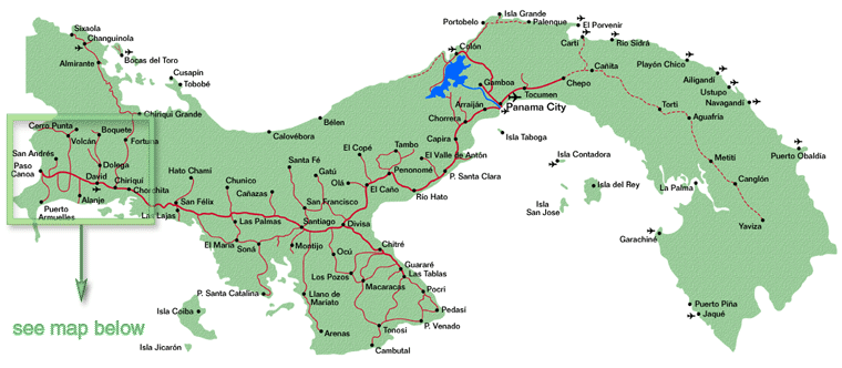
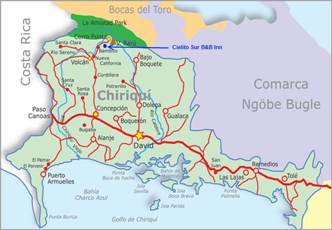
We are located in the hamlet of Nueva Suiza between the villages of Volcan and Cerro Punta in the Western highlands of the
Chiriqui province. Chiriqui is known as the "valley of the moon" by the Ngobe-Bugle Indians. The Chiriqui province borders with
Costa Rica and is where Panama's highest peak, the Baru Volcano, rises to the height of 3,475 meters (11,400 ft). Volcan and Cerro Punta are on the western slope of the Baru Volcano while Boquete is
on the eastern slope.
|

|

|
|
For your convenience, we can make all the necessary
arrangements and connections for you in Panama. We can arrange from airport pickup and transfers to reserving and purchasing local
airline tickets. Just select the package on our secure reservation form.
If you are in Panama City you can get to David, the provincial capital either by:
|
| Driving from the Enrique Malek Airport in David: Click here for a map of David, Chiriqui from Wikimap Click here for a map of Volcan, Chiriqui from Wikimap
Turn left at the Police booth, when you depart the airport and proceed 3.4 kms (2.1 miles).
When you reach the police station which will be on your right, turn left at the traffic light and head North on Calle Miguel Brenes (also known as Calle F Sur). Continue on Calle Miguel Brenes for 1.8
kms (1.1 miles), go past the McDonald's and Super 99 until you come to the traffic light on the main 4 lane Pan-American Highway. Turn left and head West on the Pan-American Highway to the town of Concepcion.
From Price Smart and the Mall Chiriqui in the outskirts of David to the turn off in Concepcion is about 21.2 kms (13.2 miles), and the drive will
take approximately 15 to 20 minutes.
|
|
Arriving into the town of Concepcion, take the road to the right
after the Romero Supermarket and the Cochez hardware store. There is a green road sign indicating the way to the village of Volcan. It is 33.4 kms (20.8 miles) from Concepcion to Volcan and it takes about 35 to 40 minutes.
|
|
In the village of Volcan you will turn right at the Puma
gas station which will be on your left, across from the Police Station and head towards the village of Cerro Punta. From the Police
Station it's 10.3 kms (6.4 miles) to Cielito Sur Bed & Breakfast Inn.
|
|
If you have a GPS unit our coordinates are: N 08°50.918' latitude and W 82°35.811' longitude
|
|
We're easy to find.
|
|
If you can't find us, no need to worry.
Just give us a quick call at 771-2038 or 6602-3008 and we'll meet you and lead you to us.
|
| Click here to see FAQ's |
|